Land Fast Ice Motion
The land fast ice motion products monitors the motion land fast ice in the Canadian Arctic.
File Provider (EO Team)#
Product Description#
| Service Name | Description | Data Owners | File Type |
|---|---|---|---|
| Motion of land fast ice | Monitors the motion land fast ice in the Canadian Arctic. | John Bennett | .geotiff |
Ancilliary Information#
- Product set-up prerequisites:
- AOI
- Time window
- Scihub location
- Sentinel-1 pair
- Coresight AWS s3 location
Naming Convention#
The following naming convention applies to all Land Fast Ice Motion files sent to Coresight:
YYYYMMDDThhmmss_YYYYMMDDThhmmss_ID_fasticemotion.geojson YYYY - YearMM - MonthDD - Dayhh - Hoursmm - Minutesss - SecondsID - Unique IDExample:
20211212T121743_20211218T121830_000659_fasticemotion.geojsonSymbology Map#
Land Fast ice motion product display the motion of the land fast ice with 8 classes of speed. Classes are defined as:
| Label | Color |
|---|---|
| 0 to 0.1 knots | #1d9bc2 |
| 0.1 to 0.2 knots | #84d9d6 |
| 0.2 to 0.3 knots | #b2dbda |
| 0.3 to 0.4 knots | #e1f2d0 |
| 0.4 to 0.5 knots | #f4fa82 |
| 0.5 to 0.6 knots | #de821f |
| 0.6 to 0.7 knots | #de251f |
Coresight#
Developers#
- Jeremy Hetzel
Processing#
Description#
Data processing takes place locally on C-CORE servers, the products of the processing are uploaded to the cloud. Once the products are on the cloud an ingester converts, creates, and stores files and metadata products to make the products accessible to the online web service.

Ingester Script#
The bulk of the ingestion work on each file is done in the cloud and the script can be found in the ice-drift-ingester repository.
Ingester Functions#
File receiving: The GRD data is acquired from Copernicus Open Access Hub (Scihub) which is queried daily for repeat-pass pairs covering areas of interest.
Initial storage: The Land Fast Ice Motion raster products generated from the GRD data by the Speckle Tracking algorithm are uploaded to an AWS S3 bucket.
File conversion: Once the raster products make it to S3 bucket, the ice-drift-ingester converts them to Cloud Optimized GeoTIFFs and creates raster tiles which are served to the Floe Edge Service.
STAC catalog: The ice-drift-ingester catalogs the metadata as a STAC item.
Final storage: The newly created STAC items are added to Firestore which makes the raster tiles available to the Floe Edge Service.
File Upload Operations#
The raster products are converted to cloud optimized geoTIFFs and a colour map is applied to them. After these steps are completed, the products are uploaded to an AWS S3 bucket. These operations are handled by storage.py and colormap.py. The associated STAC catalog is updated by a function in synchronize.py. All three files, storage.py, colormap.py, and synchronize.py can be found in the coresight-processingchain repository.
Ingester Functions#
Once the products are on S3, the ice-drift-ingester produces raster tiles which are then served to the floeedge service. The ice-drift-ingester can be found in the ice-drift-ingester repository.
Service Interface#
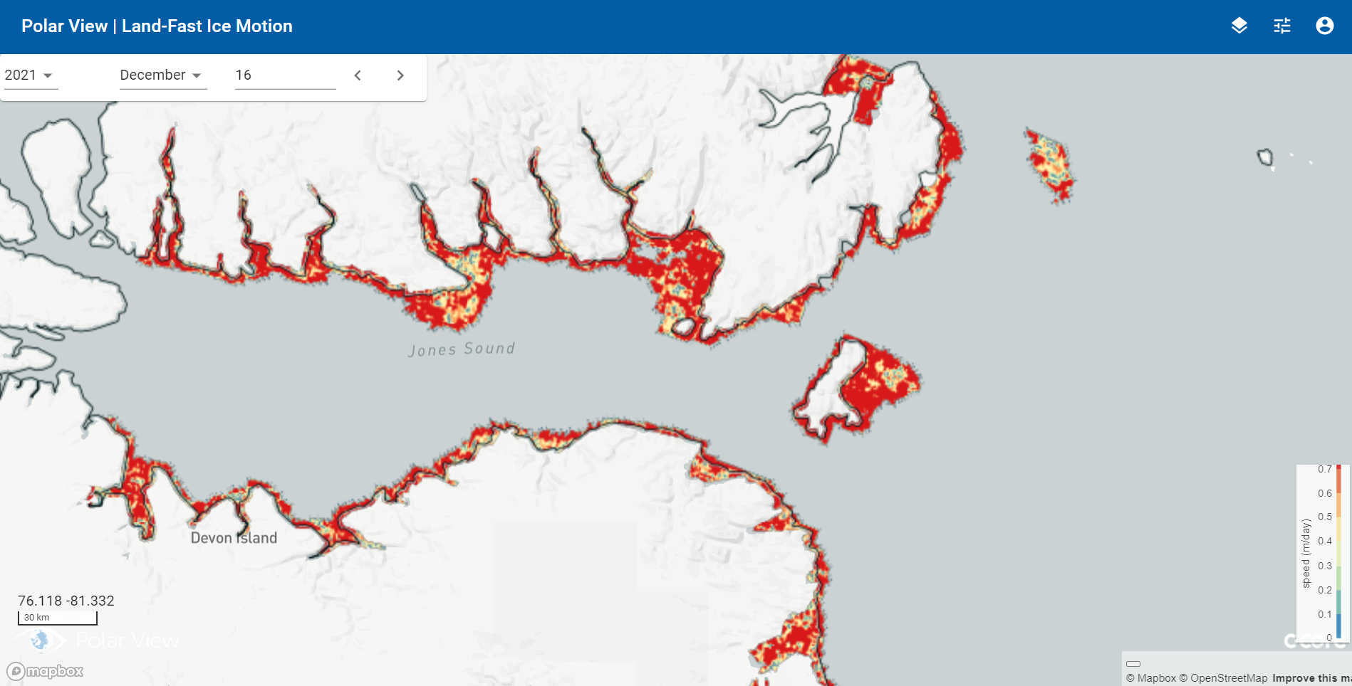
- Land fast ice on the Floe edge web interface (figure below):
- The web interface displays the most recent land fast ice data.
- The date fields can be used to select seasons, month, and day.
- The upper right square button allows the user to switch between the different services offered.

Algorithm Development#
Speckle tracking is a technique that measures feature motion between two images by optimizing patch intensity cross-correlation. It is commonly used for estimating glacial motion, however in this technique was applied to measure motion of land fast ice. The products that are generated by the speckle tracking process are raster images with pixel values indicating the speed of the fast ice movement over the time period covered by a pair of repeat-pass InSAR images. The SNAP speckle tracking algorithm is referred to as “offset tracking” and works with Sentinel-1 ground range detected (GRD) repeat-pass image pairs. It involves three steps:
- Orbit correction of the individual images (SNAP “Apply Orbit File” process)
- Co-registration of the image pair (SNAP “DEM assisted co-registration” process)
- Speckle tracking (SNAP “Offset Tracking” process) SNAP’s Speckle tracking algorithm was integrated into the floe edge service by uploading the resulting land fast ice products to coresight’s AWS s3 bucket.
The speckle tracking algorithm is able to process both IW and EW mode Sentinel-1 products in the Canadian Arctic. The combination of EW and IW processing allows high resolution IW outputs when coverage is available, mixed with lower resolution but more frequent EW-derived products during the time periods in between IW acquisitions.