Tidal Cracks
The tidal crack products are used to monitor to monitor the location of tidal crack and polynyas on land fast ice in the Canadian Arctic
File Provider (EO Team)#
Product Description#
| Service Name | Description | Data Owners | File Type |
|---|---|---|---|
| Tidal Cracks | The location of tidal crack and polynyas in the Canadian Arctic | John Bennett | .geotiff |
Ancilliary Information#
- Product set-up prerequisites:
- AOI
- Time window
- Scihub location
- Sentinel-1 InSAR pair
- Coresight AWS s3 location
Naming Convention#
The following naming convention applies to all Tidal Crack products sent to Coresight:
YYYYMMDDThhmmss_YYYYMMDDThhmmss_ddhhmm_swath1_fasticecoherence.tiff YYYY – YearsMM – MonthDD – Dayshh – Hoursmm – Minutesss – Secondsddhhmm – Delta Timedd – Dayshh – Hoursmm - Minutes
Example:
20211212T130738_20211224T130738_001953_swath1_fasticecoherence.tiffFile Uploading Instructions#
- All files should be uploaded to Coresight’s Amazon S3 Bucket:
- Fill out the Coresight Product Onboarding Checklist for new products.
Coresight#
Developers#
- Jeremy Hetzel
Processing#
Description#
Data processing takes place locally on C-CORE servers, the products of the processing are uploaded to the cloud. Once the products are on the cloud an ingester converts, creates, and stores files and metadata products to make the products accessible to the online web service.

Ingester Script#
The bulk of the ingestion work on each file is done in the cloud and the script can be found in the Ice-drift-ingester repository.
Ingester Functions#
File receiving: The SLC data is acquired from Copernicus Open Access Hub (Scihub) which is queried daily for repeat-pass pairs covering areas of interest.
Initial storage: The InSAR coherence raster products generated from the SLC data by the Tidal Crack processing chain are uploaded to an AWS S3 bucket.
File conversion: Once the raster products make it to S3 bucket, the ice-drift-ingester converts them to Cloud Optimized GeoTIFFs and creates raster tiles which are served to the Floe Edge Service.
STAC catalog: The ice-drift-ingester catalogs the metadata as a STAC item.
Final storage: The newly created STAC items are added to Firestore which makes the raster tiles available to the Floe Edge Service.
Service Interface#
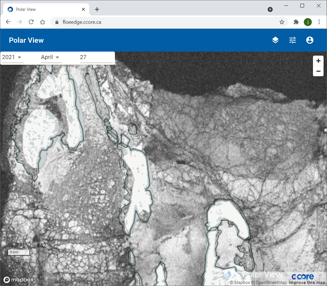
- Tidal cracks on the Floe edge web interface (figure below):
- The web interface displays the most recent tidal cracks.
- The date fields can be used to select seasons, month, and day.
- The upper right square button allows the user to switch between the different services offered.

Algorithm Development#
The tidal crack products are derived from InSAR coherence algorithm. Since the InSAR algorithm operates on Sentinel-1 Single Look Complex (SLC) data, with IW mode SAFE files typically being 7000 MB in size compared to 1600 MB for GRD products, it was found that the processing chain was RAM-limited due to the amount of memory required for processing the larger SLC files. Since the InSAR algorithm required more RAM than was available, the system needed to swap data in and out of main memory, resulting in very slow processing times and sometimes aborting prematurely due to errors. For this reason, the processing server was upgraded from 32 GB of RAM to 256 GB of RAM. This significantly improved the InSAR processing speed, and the algorithm typically uses no more than 50% of the available RAM following the upgrade. InSAR coherence maps serve as an additional product to help characterize land fast ice. The processing steps used in this process are listed below:
- Single Look Complex (SLC) data acquired with suitable baseline.
- Images are co-registered into a stack using SNAP’s TOPS co-registration with Enhanced Spectral Diversity. The image that was acquired earlier is selected as the master and the other image is selected as the slave. The pixels in the slave image will be moved to align with the master image with the help of the orbital ephemeris data. Accurate registration is very important and can have a significant impact on ice motion.
- InSAR processing is executed followed by debursting in order to produce a coherence map.
- Since the images cover a larger area than the fast ice area, a subset of the co-registered stack are created that contains the fast ice.
- The InSAR coherence product displays the coherence of the fast ice between master and slave images.
- Non-coherent areas are assumed to be tidal cracks. The raster coherence maps are created to help characterize the land fast ice, delineating the tidal crack locations.
- The coherence products are converted to cloud optimized GeoTiff format in a similar way to the speckle tracking products, so that they can be published via the PVIS web portal. The InSAR coherence outputs were found to be quite large and therefore are downsampled prior to uploading for display on the floe edge service. The outputs are downsampled by a factor of two in each dimension, resulting in GeoTiff outputs of approximately 200 MB rather than the full resolution outputs of about 800 MB. This change in resolution was found to be acceptable visually when the products are displayed on the PVIS front end.
The InSAR coherence algorithm can process both IW and EW mode Sentinel-1 products in the Canadian Arctic. The combination of EW and IW processing allows high resolution IW outputs when coverage is available, mixed with lower resolution but more frequent EW-derived products during the time periods in between IW acquisitions. Below is an example of Tidal Crack product (April 17, 2021) on the Floe Edge Service in the Sanikiluaq area (Belcher Islands)